

Now, Ive looked at role-playing game maps of all kinds and in all of those, including the larger world maps that were included with this publication, Ive never noticed that hexes, or sometimes squares, were each individually created and then stitched together as Arneson suggests in this subsection. Do you see that hex in that photocopy of page 41 above? Dave proposes that I should lay out all manner of terrain in those 88 plots based on dice rolls. Intriguing. He then suggests that creatures may live in a plot of the hex or migrate to this hex from another hex based on dice rolls.

As a matter of fact, its so fascinating to me that I will now attempt to draw my own map based on rules outlined in the text. I suppose I should start with an 88 plot hex and I'll design this first hex the way Dave intended, by "pen and paper". Actually, I'm going to cheat a bit and use a pencil because I'm not all that confident that I wont need an eraser. Here it goes:

Twelve squares across, ten squares high and although you can't see it, there is plenty of room for neighboring hexes. Let's just see how this goes, shall we?
For each square (hex), roll for the following:
1 or 2 The area is heavily wooded
3 or 4 The area has hills in it
5 or 6 The area has hills and woods in it
7-8-9 The area is open country with few trees or hils
0 The area has a gastly[sic] swamp in it
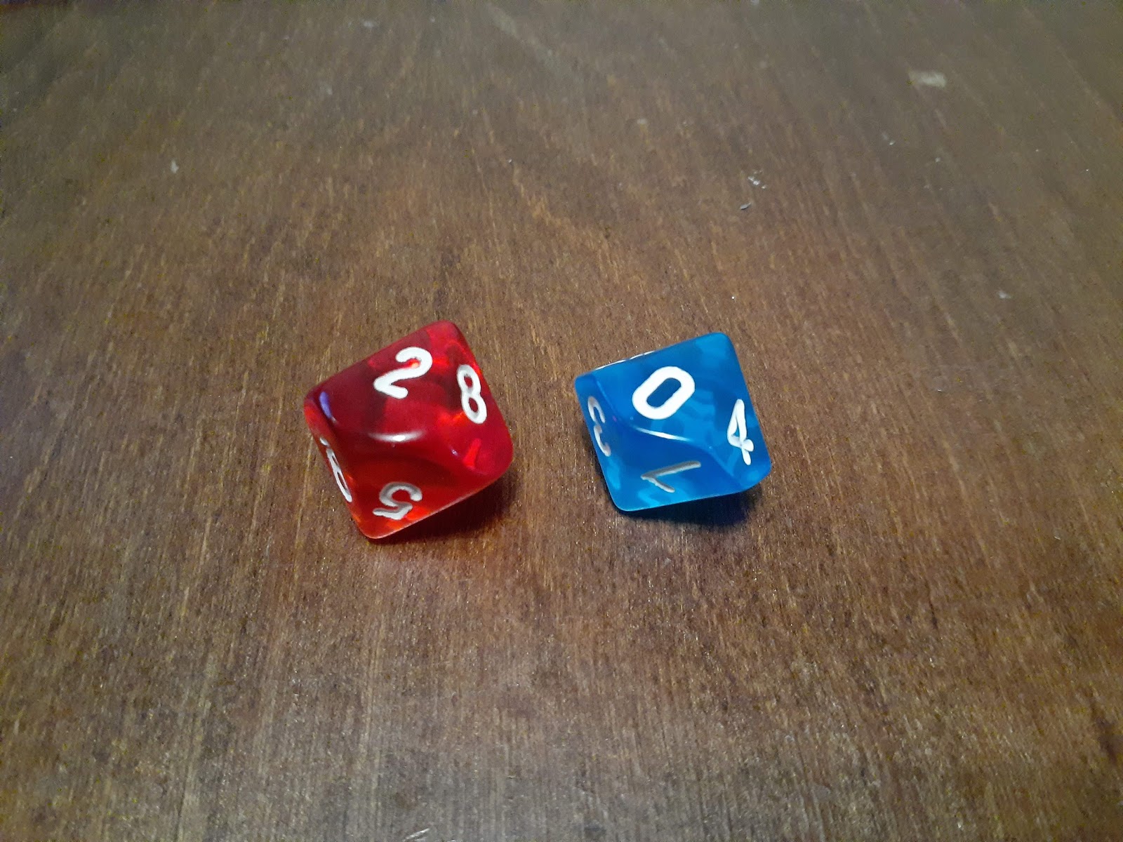
So, I'll be rolling 1d10, that's one 10 sided die for anyone who's not explicitly familiar with role-playing game terminology.

Well, it looks like this new world is going to be a very cheery place. It'll start off as a ghastly sick swamp!
Swamp: Roll the percentage die[sic], reading left to right, for
the percentage of area that is a swamp. Then roll for it's
location for each subsection[sic???]. For the remaining open
areas there is a 10% chance a one contour hill, 10% chance of
a woods, and a 10% chance of both, there is a 70% chance that
it is open. There is a 5% chance of a human habitation.
Okay, just hold your first fantasy campaign horses for a second! Several things need to be clarified and one part needs to be contemplated. (Remember my commentary in my last post about how there seemed to be no editor to this manual?) First, to my knowledge percentage or percentile dice (plural) have always been two dice and never one die (singular), which is probably what Arneson meant. In the early days of RPG's, people simply rolled 2d10 and read the numbers left to right as they fell, just like this:

Then roll for it's location for each subsection.
David sort of tells us what to roll later on another page but not how to determine the results. On the last page of the "Drawing Your Own Map Section" he says
Roll percentile dice reading one as 'tens' and the other as
'ones' (roll again on '89' or higher).
Here's where I'll need to be creative. Instead of having rolled for percentage of swamp earlier, I'm going to say that I rolled for number of plots of swamp and I would have re-rolled on an 89 or higher. That saves me from the extra math of determining what 58% of 88 is. Now I'll have to determine where these 58 plots are located within the 88. Because of the way the plots are laid out by the original illustrator, if I were to simply roll for where the dead center of the swamp is, that would leave me two options for how the ghastly sick swamp spreads out from there. If spread out by strictly numbers 1 through 58, it would definitely leave our area in question scattered in different parts of the hex. If the swamp just spreads evenly outward from the center point it may have an unnatural look to it. I'm not sure so I guess I'll just have to try both ways. Now I'll roll 2d10 (re-rolling '89' and above) to find where the center of the swamp is and I'll use the same answer to plot both hexes.

 Hex "1a" starts at plot 54 and encompasses 29 thru 86 (58 plots total).
 My initial thought about how this ended up is that it's too boxy and I'm not thrilled with that tiny two-plot triangle on the right side. What if the dice determine there is a hill there? Since each plot represents 1 mile, I suppose a triangle shaped 1 mile long hill would be okay.
 Hex 1b starts at plot 54 and then spreads out as evenly as i can manage for a total 58 plots total.
 I like the way this one looks much better than the other but I'm still not crazy about how the bottom and right sides of the swamp land will appear brutally straight on a map. Again though, keeping in mind that each plot represents one mile, I suppose the South and East boundaries of the swamp could vary a half mile either way of center of the lines on the map. Would this sort of straight line nitpicking affect anything other than aesthetics? I guess not.
To uphold the true spirit of what Dave wrote:
For the remaining open areas...
Our instructor seems to indicate multiple areas. With this in mind, I should probably stick with 1a or a variation of it to allow for more than one remaining area to populate with possible trees, hills, etc.
By this point, I have interpreted and created new rules for previous steps in this creative process. Why couldn't I do that now to arrive at a swamp position that I'm pleased with? Here is my solution which I'll apply to hex "1c".
By this point, I have interpreted and created new rules for previous steps in this creative process. Why couldn't I do that now to arrive at a swamp position that I'm pleased with? Here is my solution which I'll apply to hex "1c".
 To create this new hex, I began filling in plots around 54 until I encountered a plot touching the edge, at which point I would roll 1d6. On a roll of 1 to 3 the swamp was not in that plot but if 4 thru 6 was rolled I designated it a swamp. It's a little more work, but I think it makes for a more natural looking geological occurrence and also creates more than one open area as Dave seems to have intended in the original text. As a bonus, if any adjacent hexes to the south, southeast, or northeast are also swamps I will still have the option of connecting to these border occupying swamp plots to make a multi hex swamp.
For the remaining open areas there is a 10% chance a one
contour hill, 10% chance of a woods, and a 10% chance of both,
there is a 70% chance that it is open. There is a 5% chance of
a human habitation.
It looks as if there are only two open areas. To clarify, I'll rolling the blue and red dice with 1-10% being a one contour hill, 11-20% woods, 21-30% both a one contour hill and a woods, or 31-100% being "open" which is probably grassland. Also, there will be a second roll for each area and I'll use the double green dice where 1-5% indicates that it has a human habitation and 6-100% meaning no humans. I'll do the larger area first:


The results indicate 40% or open and 8% or no human habitation (so close!). Now for the smaller area:

These numbers are 20% indicating woods and 9% or NO HUMAN HABITATION (what the hell?).
There are actually rules for open areas and woods both are similar to how the swamp is determined. However blogging this exercise is becoming far more detailed than I originally envisioned. I'm going to complete the rest of the hex independently and then probably do surrounding hexes just to get a feel for the new world. I have the best intentions of making a follow-up blog post showing the completed map.
As I'm finishing up this blog post I'm actually realizing that it has gotten away from what I originally wanted. For future posts, I think I'll shoot for a short and to the point approach, because I'm less interested in writing and more interested in learning. Thanks for reading and feel free to comment.
No comments:
Post a Comment